

There is a convenient fiction at the heart of Bali’s tourism industry: the idea that its green rice terraces exist as monumental scenery, sculpted for visitors to admire over smoothie bowls and drone shots. In reality, the terraced slopes that fill social feeds are the working surface of a fragile agricultural system known as subak, still feeding communities and still governed by temple rituals, irrigation rules and farmer negotiations. Treating them as a backdrop for leisure is not simply disrespectful; it helps push the system toward the very breaking point that UNESCO has now formally warned about.
Subak: A Living System, Not a Scenic Monument
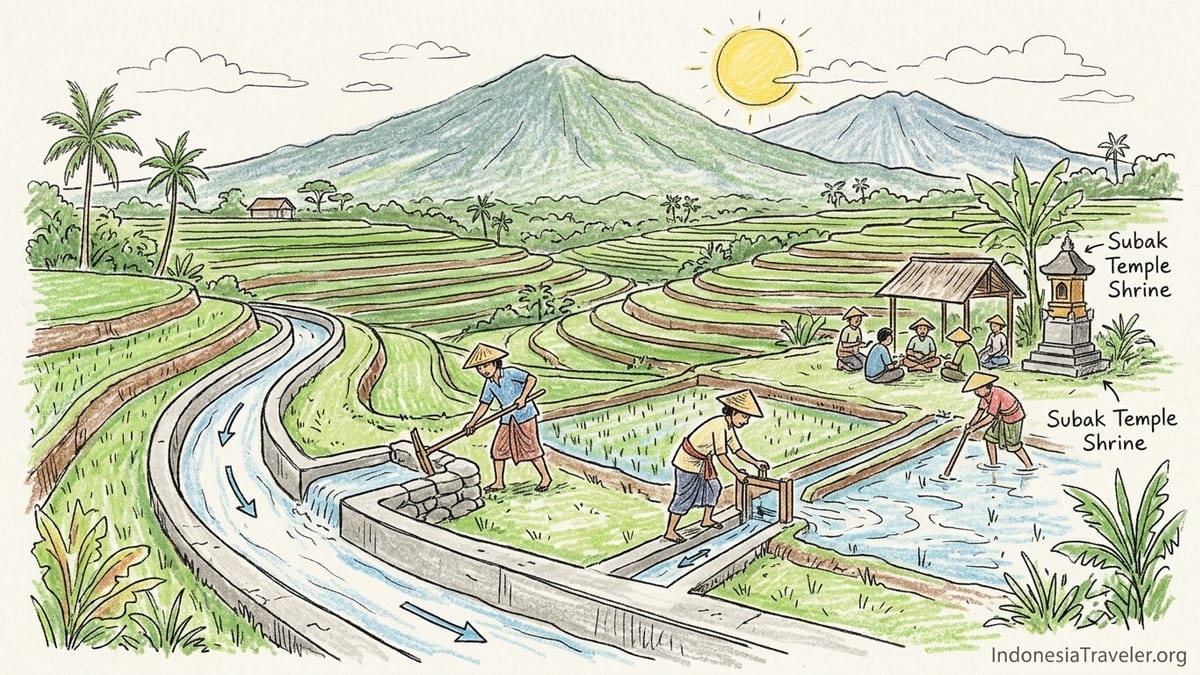
Bali’s famous rice terraces are not stand-alone attractions. They are the visible skin of subak, a cooperative irrigation system that has tied together farmers, water temples, canals and social obligations for more than a thousand years. What looks like a sweeping amphitheatre of rice at Jatiluwih, for example, is actually the outcome of dozens of upstream decisions: which canal to open, which terraced plot to flood, when to plant, when to drain. Every stone diversion weir and muddy footpath carries responsibility, not just charm.
UNESCO’s listing of the “Cultural Landscape of Bali Province: the Subak System as a Manifestation of the Tri Hita Karana Philosophy” describes a web of roughly 1,200 subak water collectives across Bali and a World Heritage property that covers about 19,520 hectares. This landscape is divided into five key components: the Supreme Water Temple Pura Ulun Danu Batur, Lake Batur, the Subak Landscape of the Pakerisan Watershed, the Subak Landscape of Catur Angga Batukaru, and the Royal Water Temple Pura Taman Ayun. Those names almost never appear on tour brochures, yet they are the backbone of the terraces promoted under vaguer labels such as “Ubud rice fields” or “Bali rice terrace experience.”
Within each subak, farmers form an association that decides how water from shared canals will be allocated and when fields should be planted or left fallow. Decisions are meant to be collective, because if one farmer floods his fields too early or switches from rice to a thirstier cash crop, it can upset pest cycles and water availability for everyone downstream. That is why narrow concrete or earth channels that tourists step over for a photo are not decorative features. They are the working arteries of a system whose collapse would be felt first by local households, not by visitors.
This is the gap between the reality of subak and the tourism narrative. When marketing reduces terraces to scenery, it erases the daily work of farmers who negotiate access at temple meetings and physically clean the canals so others can earn an income. It also makes it easier for visitors to walk through young rice plants or sit on irrigation walls without understanding exactly what they are damaging.
Tri Hita Karana: Philosophy Turned Marketing Slogan
Tri Hita Karana, the guiding philosophy behind subak, is now printed on hotel brochures and conference banners across Bali. It is usually translated as “three causes of well-being” or “three harmonies,” referring to the relationship between humans and the divine, between humans and each other, and between humans and nature. In tourism marketing, it is often treated as a soft slogan, proof that Bali is inherently balanced and therefore an ethical destination by default.
Inside the subak system, Tri Hita Karana is not abstract. It structures real, often uncomfortable, decisions. The “harmony” between humans and nature might mean agreeing to plant rice varieties that produce less short-term cash but fit the local water supply and pest cycles. The “harmony” among people can involve collective sanctions on a farmer who ignores planting schedules, or a temple priest reminding a hotel owner that drilling an extra well could dry out lower terraces. These are negotiations, not automatic states of bliss.
Visitors who hear Tri Hita Karana described only as a timeless cultural principle miss the contemporary arguments around it. For example, when a new villa complex above Jatiluwih seeks to tap into springs that subak members rely on, the question is not whether harmony exists. The question is who has the power to claim that their version of harmony, usually expressed as economic development, should override another group’s material security. Framing Tri Hita Karana as a feel-good brand phrase hides these conflicts behind a veil of “Bali magic.”
Seen in that light, the terraces and temples within the UNESCO property are not symbols of harmony that can absorb endless development. They are test cases of whether Bali can keep a complex philosophy grounded in water sharing, ritual calendars and farmer livelihoods, instead of flattening it into a decorative motif for wellness resorts and Instagram captions.
The Five UNESCO Components: What They Really Represent
The first component of the UNESCO listing is Pura Ulun Danu Batur, often confused with the more heavily touristed Ulun Danu Beratan in Bedugul. Ulun Danu Batur sits on the rim of the Batur caldera, and its associated shrines look inward to Lake Batur, which UNESCO recognises as the ultimate water source for many subak systems. Rituals here are not staged performances for tourists but part of a calendar that links highland water to downstream rice harvests. When guides talk about “blessing the water,” this is the ritual context they are referring to, whether they name it or not.
Lake Batur, the second component, is not simply a scenic highland lake dotted with boats and lakeside lodgings. It is treated in Balinese cosmology as a giant reservoir whose health directly affects the fertility of land far away. Reduced rainfall, pollution from lakeside development, and increased water extraction all have ripple effects for the subaks that depend on its outflow. Any visitor activity around the lake, from motorised water sports to hotel construction, takes place in a space that UNESCO recognises as integral to the island’s food system.
The Pakerisan watershed, the third component, runs through some of Bali’s densest tourist zones, yet many visitors do not realise they are within a World Heritage landscape. In this valley, subak terraces sit beside ancient royal tombs and temples, and the same irrigation channels that sustain today’s crops once served palaces and hermitages. Here, the pressure is not just from hotels but from smaller guesthouses and cafes that incrementally occupy land which once fed local families. A room with a rice-field view often exists because a subak has already lost fields closer to town.
The Catur Angga Batukaru landscape, which includes Jatiluwih, is the largest component and contains forests, lakes and multiple subak institutions spread along the slopes of Mount Batukaru. It is here that the visual image most people associate with “Bali rice terraces” is produced, and it is here that the tension between agriculture, conservation and tourism is starkest. Finally, Pura Taman Ayun, a royal water temple in Mengwi, makes up the fifth component. It dominates guidebooks as a cultural stop but is rarely discussed as part of an irrigation governance system, yet it historically coordinated water for surrounding subaks.
Tegallalang and the UNESCO Myth
One of the most persistent misconceptions about Bali’s terraces is the claim that the photogenic slopes of Tegallalang, north of Ubud, are part of the UNESCO World Heritage property. Many social media posts, some hotel websites and even a few poorly briefed guides casually refer to them as “UNESCO-listed rice terraces.” This is incorrect. Tegallalang is not one of the five components of the Cultural Landscape of Bali Province property, nor does it sit inside the officially mapped core zones of Pakerisan or Catur Angga Batukaru.
This error matters because it has consequences. When cafes in Tegallalang market their hanging nests and swings as “UNESCO views,” they piggyback on the legitimacy of a system that imposes real obligations on farmers elsewhere. UNESCO status comes with management expectations, reporting duties and now, in 2025, pointed criticism of harmful tourism developments. Tegallalang’s terraces, while also shaped by subak practices, have largely been surrendered to commercial tourism that prioritises quick-turnover photo spots and ticketed platforms over long-term farming viability.
At Tegallalang today, visitors pay small entry fees at multiple village-run posts, then run a gauntlet of swings, heart-shaped bamboo lookouts and “I love Bali” signs. Between these, farmers still plant rice, but they do so in narrow strips fragmented by paths, selfie areas and informal stalls. Water channels are stepped on, sat on and occasionally broken to allow new access paths. When visitors believe they are in a UNESCO site, they often assume that somewhere, a management plan must be protecting the landscape. In Tegallalang’s case, the protections are weaker and more fragmented than the branding implies.
Correcting the myth is not an attack on Tegallalang’s farmers, many of whom rely on tourist spending to supplement shrinking rice income. It is an argument for honesty. If visitors want to see how a UNESCO-recognised subak landscape is supposed to function, they should know to look instead to places like Jatiluwih in Catur Angga Batukaru, or to community-led walks in parts of the Pakerisan watershed where tourism is still negotiated as a secondary use of agricultural land, not its main purpose.
UNESCO’s 2025 Warning: A System at a Tipping Point
In 2025, the World Heritage Committee adopted Decision 47 COM 7B.75 on the Cultural Landscape of Bali Province. Buried in the bureaucratic language is a stark message: the subak structures that underpin Bali’s small-scale rice terraces were described as “highly sensitive and fragile” and appearing to be “at a tipping point.” The Committee noted “tourism-related development” and land-use pressures as key drivers and called for urgent enforcement of permits and land sale regulations, as well as stronger socio-economic support for farming communities.
This does not mean UNESCO has removed Bali’s subak system from the World Heritage List. The property remains inscribed, but the 2025 decision is effectively a yellow card. It signals that if current trends continue unchecked, the very attributes that justified the listing may erode to the point where the site’s Outstanding Universal Value is compromised. In plain language, that could mean more formal danger listings in the future, or in a worst-case scenario, delisting. For now, UNESCO is pressing Indonesia to treat land conversion, speculative development and unregulated tourism ventures as threats to food security and cultural continuity, not just as signs of economic growth.
For travellers, this should puncture the illusion that buying a ticket to a UNESCO-branded terrace is automatically a positive act. UNESCO is not a quality label that certifies a site as well managed or low impact. It is a monitoring framework that, in Bali’s case, now publicly acknowledges that the system is under severe strain. Visitors who read Decision 47 COM 7B.75 will find that the most serious concerns are not about visitor numbers themselves but about how tourism reshapes power over land and water.
The decision welcomes steps like the National Strategic Spatial Plan for the Subak-Bali Landscape and new spatial plans, but notes that these are not enough if subak authorities keep losing practical influence over what happens around their fields. Authorities can draft plans in provincial offices, but if a road expansion proceeds without meaningful consultation with farmer groups, or if villas quietly buy up multiple plots within a single subak, the balance that Tri Hita Karana seeks to maintain is disrupted regardless of what documents say.
Jatiluwih as Case Study: Fees, Trails and Real Impacts
Jatiluwih, in the Catur Angga Batukaru component, is where UNESCO’s ideals, local agriculture and mass tourism most visibly collide. As of October 2026, the official Jatiluwih management body lists the foreign adult entrance fee at 75,000 Indonesian rupiah, with lower rates for Indonesians and children. That single gate fee covers access to the village road that winds through the terraces, parking areas and the main viewpoints used by tour buses and independent travellers alike. Separate charges apply for guided trekking routes, cycling packages and activities such as drone photography or special night-time events.
On the ground, this means the visitor day at Jatiluwih can look very different depending on choices. A guest who arrives by private driver, pays the entrance fee, snaps a few wide shots from the main lookout and leaves within 40 minutes has contributed limited income beyond the ticket. Another who books a half-day guided walk along marked trails, eats at a locally run warung that sources rice from nearby fields and buys coffee grown in the surrounding highlands circulates more money through the local economy. The first visitor also exerts less physical pressure on the narrower trails and channels in the valley. The question is not whether tourism is good or bad, but how its patterns can support farming rather than displace it.
Jatiluwih’s trail network is divided into colour-coded walking routes, ranging from short loops visible from the main road to longer descents into the lower terraces. Signs at the village entrance and on some posts instruct visitors to stay on marked paths, avoid stepping on rice bunds and refrain from entering flooded fields. These instructions are not just about safety. A single misplaced footprint can break the compacted earth walls that hold water in a paddy. Repairing that break costs a farmer time during already tight planting schedules and may waste irrigation water allocated under subak rules.
Cycling operators, some local and some based in South Bali, now run downhill or cross-country tours that pass through or start from Jatiluwih. The best of these coordinate with subak leaders, use established farm roads, and schedule rides to avoid peak working hours when farmers are bent over young rice. Others choose routes mainly for drama, sending groups along dikes not designed for repeated tyre traffic. For visitors, asking explicitly whether a tour has agreements with Jatiluwih’s subak organisations is not a minor detail. It is a way to check whether your ride is helping pay for the landscape you came to enjoy or simply wearing it out.
Roads, Villas and the Economics of Leaving the Land
Behind UNESCO’s concern about a tipping point is a set of very grounded realities. Road expansion, hospitality development and changing land use are reshaping Bali’s subak landscapes field by field. In districts that feed into the World Heritage property, farmers describe asphalt pushing steadily closer to terraces that once felt remote. A newly widened road that improves tourist access to a viewpoint almost always raises land prices along its length, putting pressure on owners to sell narrow slices of their paddies for parking, cafes or homestays.
For many farming families, the decision to sell is not irrational. Rice prices have not kept pace with Bali’s cost of living, and younger generations often prefer wage work in hotels, restaurants or offices over unpredictable harvests. If a land broker offers a life-changing cash sum for a strip of terrace that a family has struggled to maintain, refusing it in order to uphold the subak ideal can feel like a luxury. In Jatiluwih and similar villages, this creates a paradox. Visitors arrive seeking “authentic” rice landscapes while the economic system quietly nudges farmers to exit the very activity that sustains those landscapes.
Hospitality developers often present themselves as allies of subak, emphasising eco-resort branding, yoga shalas with rice views and occasional cultural shows. Some genuinely invest in canal maintenance, purchase local rice at above-market rates and restrict building footprints. Others use green language while effectively removing fields from production, building pools on former paddies and carving vehicle access across irrigation channels. Because subak organisations historically controlled water and planting patterns more than outright land sales, they can find themselves sidelined in these negotiations, especially when local government offices see property taxes and tourist arrivals as clearer metrics of success than sustained harvests.
The result is a slow but visible fragmentation. A subak that once managed a continuous belt of terraces around a village may now be responsible for pockets of rice surrounded by villas, parking lots and ornamental gardens. Irrigation planning becomes harder, pest cycles become less predictable, and spiritual obligations linked to planting and harvesting ceremonies are disrupted. For visitors, this fragmentation is often invisible, masked by clever photography angles that exclude nearby construction. Yet it is precisely this drift that UNESCO’s 2025 decision warns against.
Beyond the Backdrop: How Visitors Can Engage Differently
Criticising the commercial reduction of rice landscapes to backdrops does not require concluding that all tourism is harmful or that visitors should stay away. It means being honest about the conditions under which tourism can coexist with, and even reinforce, a living subak system. There are concrete ways for travellers to move from passive consumption of views to more responsible participation.
At Jatiluwih, one option is to hire a local guide from the community-run posts near the main car park or from the official management office, rather than relying only on an outside driver’s commentary. Local guides can explain which channels feed which hamlets, how planting schedules are decided, and why certain terraces are left fallow. They can also steer you onto routes that minimise interference with farmers at work and point out spots where stepping off the path has already caused collapses in terrace walls.
Simple behaviour choices also matter. Staying on signposted trails, keeping out of flooded paddies, and avoiding sitting or posing on narrow bunds or concrete canal edges all reduce damage. If you want the classic “in the rice” photograph, choosing a viewpoint where paths are wide and clearly used for access, rather than cutting across a young crop, is a small concession that respects months of labour. Where drone use is permitted for an extra fee, flying high and brief instead of repeatedly buzzing low over workers is a basic consideration.
Economic decisions can reinforce this respect. Eating at warung and small restaurants that employ local residents and, where stated, buy rice from the village sends a clearer signal than spending the entire visit at international-style cafes on the main tourist corridor. Purchasing locally grown coffee, cacao or red rice to take away means some of your travel budget stays tied to agriculture rather than to speculative property. When considering accommodation, choosing guesthouses within existing village clusters instead of new stand-alone villas in the middle of terraces reduces pressure to convert more fields.
FAQ
Q1. Are Bali’s rice terraces created mainly for tourism?
They are not. The terraces are the working surface of the subak irrigation system, designed over centuries to grow rice and manage water, long before tourism arrived.
Q2. What exactly is a subak?
A subak is a cooperative association of farmers that manages irrigation water through canals, weirs and shared rules, tied to specific water temples and ritual calendars.
Q3. Which sites make up Bali’s UNESCO subak World Heritage property?
The property includes Pura Ulun Danu Batur, Lake Batur, the Subak Landscape of the Pakerisan Watershed, the Subak Landscape of Catur Angga Batukaru and Pura Taman Ayun.
Q4. Is Tegallalang rice terrace part of the UNESCO listing?
No. Tegallalang is often marketed as “UNESCO” but it is not within the five officially inscribed components of the Cultural Landscape of Bali Province.
Q5. How much does it cost to visit Jatiluwih rice terraces?
As of late 2026, the official foreign adult entrance fee at Jatiluwih is around 75,000 rupiah, with lower rates for Indonesian citizens and children.
Q6. Why is UNESCO worried about Bali’s subak system?
In 2025 UNESCO warned that tourism-related development, land conversion and weakening subak authority are pushing parts of the landscape toward a critical tipping point.
Q7. Does UNESCO’s 2025 decision mean Bali lost its World Heritage status?
No. The site remains on the World Heritage List. The decision is a serious warning, not a delisting, and calls for urgent protective measures.
Q8. How can visitors avoid damaging irrigation channels or crops?
Stay on marked trails, do not enter flooded paddies, avoid stepping on terrace walls or canal edges, and follow any instructions from local guides or posted signs.
Q9. Is it better to visit Jatiluwih or Tegallalang?
Jatiluwih lies within the UNESCO property and offers marked trails and broader landscapes; Tegallalang is closer to Ubud but more commercialised and heavily developed.
Q10. What practical steps can travellers take to support subak farmers?
Hire local guides, spend money at village-run warung and homestays, buy local agricultural products, respect the fields, and question tours that treat terraces as mere photo sets.